Pure jealousy! One of my weegie (Glasgow) born colleagues' feeble attempt at parody. Mine first (missive to all colleagues to direct them to this blog) followed by his repost - a challenge for all East coasters and foreigners!
"Dear colleagues,
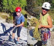
I will be departing on leave from tomorrow afternoon until the 1st of November. Husband Brian and I will be attempting to walk through the USA from Mexico to Canada – the aim is to leave a continuous set of foot prints from one border to the other. We’ve done something similar along the Pacific Crest Trail in 1998 and succeeded in walking the whole way (seems a long time ago…). This time we’ll be on the Continental Divide Trail which goes through New Mexico , Colorado , Wyoming (Yellowstone) and Montana , roughly following the line of the Rocky Mountains . 2800 miles – averaging 20 miles per day and stopping for resupply roughly every 5-7 days (depending on where a road to a town crosses the trail or we pass a friendly ranch, ranger station or petrol station that accepts supply parcels we’ll sent to ourselves). We’ll be camping all the way (looking forward to hearing the coyote at night).
We expect to be within reach of public internet access probably every other week or so and will try to post photos and a blog. I know that the SEPA internet IS setting isn’t amenable to allowing access to our blog at work, but the photo site seems to be acceptable. So if you wanted to see how we are getting on, feel free to “pop in”."
Glasgow Version:
"Am gauni Paisley fur ra holidaze at Eestur,
Ra Police report hus phot-eez fae thi last paste-in a goat there. I um hopin’ to hit social services every other day as they huv drop in ceturs in Borheed Charstlon and Dykebar fur battered wives ( I asked if I could huv a go the last time I wuz at the Back Snedon Centre but they said that wuzni appropriate and wid a no cum back). The Holiday will be oan the Sectarian Divide Which runs mostly through Thrushcraigs and annexes the Charslston Coldellera which has a number of known hot spots. The kids an I dae this every year couz it cheap an the Sally Army gie oot survival boxes wae Ritz crackers and Primula cheese which geez the wains a hot meal at least wance a day if yi pit them in the microwave. Yi can also huv a Hot “Spring Release” operated shower as well but they check fur nits so it takes a basturd long time so we may furgo that pleasure. We wull be mostly taking the bus coz walking wid expose us tae the wildlife to much and some of them unerston English and realise we might be ripin the pish. Looking forward tae listenin’ tae the night sound of animals f$%kin’ or killin’ wan another ( the Foxes and birds will be a welcome interlude). We will be stayin’ at big brothers so will have intermittent internet access if I can get him af Ranger fan club site. I will however be mosltly bladered so willni be arsed tae type. If ony yis want tae keep up wi oor exciting travel itinerant itinerary; Naw! "
Tuesday 31 March 2009
Wednesday 25 March 2009
Our itinery

The map here shows our tentative itinery including an expected arrival date at towns along the way from Mexico to Canada. There are a few variations included as things could well change through the summer ! Thanks to Cookie and Paul for providing the base map.
Tuesday 24 March 2009
Maps, info and planning.......
We have gathered lots of information to help us with our walk this year. The Continental Divide Trail isn't really a complete path, but is a mix of walking trail, vehicle track, cross country routes and suggestions. Our intended start to the route from Columbus New Mexico will not actually cross the official trail or the actual Continental Divide until about 150 miles! We are choosing this route as we think it will be more interesting and it has potentially better water sources.
Brian loves maps and has collected various types for the trip starting with Delorme state road maps for an overview of each state. These provide us with a view of nearby towns, roads and route options for our walk.
We also have some Trails Illustrated maps which are available for popular areas such as Yellowstone and Glacier National Park in Montana - these are about equivalent to UK OS maps.
Our main maps though are those produced by Jonathan Ley, who hiked the trail in 2001 and has since produced maps available on CD and updated each year with hiker comments. The trail is everchanging- new trail gets built, better options are found, trail gets flooded- and Jonathan updates his maps with these details. A gr eat resource!
 eat resource!
Jim Wolf at the CDT Society also produces excellent guides to the trail, less frequently updated than Jonathans maps but again very useful and we will be carrying these.
Finally we have town guides from 'Yogi'. She has researched the details of towns near to the trail with overview street maps, useful addresses of POs, motels, gear shops, groceries, stove fuel availability. We will be thankful for these!
January walk in the Cairngorms area of Scotland across the 'Burma Road'
 In January, we did a loop walk in the central Scottish Highlands from Slochd summit up the Dulnain river , then over the Burma road and back north over the hills to the Slochd. we had some great open views across snowy terrain.
Monday 23 March 2009
Walking the Black Isle Coast.....
In January and February we walked from Fortrose to Cromarty along the coast and back via the forest tracks a few times. The distance is about 18 miles and the coastal scenery is excellent.


West Highland Way video
Hound Dog walking north of Tyndrum on the West Highland Way! (Before the rain -caw caw)
A short hike on the west highland way.....

The West Highland Way is a 90 mile trail in Scotland that travels north from Milngavie on the outskirts of Glasgow, to Fort William. Hound Dog went for a two day trip this weekend starting at Tyndrum and walking for about 44 miles to Fort William. I camped at the Kingshouse hotel at the top of Glencoe on Saturday night. My feet now feel sore!!
Subscribe to:
Posts (Atom)